1976. december 28-án jelent meg a Tanácsok Közlönyében az Országos Természetvédelmi Hivatal (OTvH) elnökének 18/1976. OTvH számú határozata a Bükki Nemzeti Park létesítéséről, és 1977. január 1-én 38774,6 ha-os védett területtel megalakult hazánk sorrendben harmadik nemzeti parkja - ugyanakkor az első, amely hegyvidéki területet foglalt magába.
1976. december 28.-án jelent meg a Tanácsok Közlönyében az Országos Természetvédelmi Hivatal (OTvH) elnökének 18/1976. OTvH számú határozata a Bükki Nemzeti Park létesítéséről, és 1977. január 1-én 38774,6 ha-os védett területtel megalakult hazánk sorrendben harmadik nemzeti parkja - ugyanakkor az első, amely hegyvidéki területet foglalt magába.
Az igazgatóság irodája 1979-ig Miskolcon volt, majd Egerbe költözött. Ma a város északi részén, Felnémeten a Sánc utca 6. szám alatt található.
A Bükki Nemzeti Park rendeltetését a védetté nyilvánító határozat így fogalmazza meg:
A nemzeti park területét az alapítást követően kétszer bővítették. 1984-ben a Bél-kő kőbányászat alól kivont délnyugati ormát - mintegy 39,8 hektár - csatolták a nemzeti parkhoz, melyből 13,4 hektár fokozottan védett terület (4/1984. OKTH rendelet). 1996-ban egy nagyobb arányú bővítésre került sor, ekkor a Délkeleti-Bükk Kisgyőr és Bükkszentkereszt közötti 3019,8 hektár kiterjedésű részével gyarapodott a nemzeti park (23/1996. KTM rendelet).
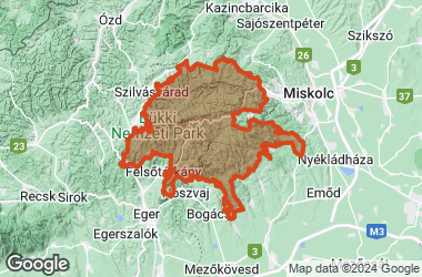
Napjainkban a Bükki Nemzeti Park csaknem az egész Bükk hegységre kiterjed, magába foglalva annak legszebb, természeti értékekben leggazdagabb részeit. 2002-ben az országos jelentőségű terület kiterjedése jogszabály szerint 41.834,2 hektár (a helyrajzi számokban időközben bekövetkezett változások szerint a nemzeti park területe 42 269 hektár). Ennek 94,27 %-a erdő, 3,35 %-a gyep (rét és legelő), 1,95 %-a művelés alól kivont terület, 0,42 %-a szántó, a fennmaradó alig 0,01 %-át pedig szőlők és gyümölcsösök teszik ki.
A védett terület nagyobb része (65 %) Borsod-Abaúj-Zemplén, kisebb része (35 %) Heves megyéhez tartozik. A nemzeti park B-A-Z megyében Dédestapolcsány, Mályinka, Tardona, Varbó, Parasznya, Miskolc, Bükkszentkereszt, Kisgyőr, Sály, Kács, Cserépváralja, Cserépfalu, Bükkzsérc és Répáshuta, míg Heves-megyében Eger, Felsőtárkány, Szarvaskő, Mónosbél, Bélapátfalva, Szilvásvárad és Nagyvisnyó települések közigazgatási területeit érinti. A nemzeti park területén belül csupán három apró, állandó lakosságú település található: Répáshuta, Ómassa és Felsőhámor (Lillafüred). Ezeknek nemcsak teljes külterülete (határa) védett, hanem a beépített belterülete is. A három településen lakók száma összesen nem haladja meg az 5000 főt, míg a BNP-t övező többi településen összesen ennek a számnak ötvenszerese, mintegy 250 000 ember él.
A nemzeti park védett területének 97,7 %-a állami tulajdonban van. Kezelője szinte kizárólag két erdőgazdaság: az Egererdő Rt. (a Bükk Ny-i felén) és az Északerdő Rt. (a Bükk K-i felén). A BNP Igazgatóság vagyonkezelésében csupán a védett területnek alig 2,5 %-a van (2002 december).
A Bükki Nemzeti Parkon belül vannak kiemelkedő fontosságú, egyedülálló természeti, kultúrtörténeti és tájképi értékeket hordozó területek, amelyek fokozott védelmet élveznek. A BNP területén ezek az alábbiak (a 18/1976. OTvH határozatban 6009 hektár szerepel mint "szigorúan védett terület"):
A Bükki Nemzeti Park fokozottan védett területeinek kiterjedése jelenleg tehát 6009 hektár (a 18/1976. OTvH határozat és a 4/1984. OKTH rendelet szerint).
A természet védelméről szóló 1996. évi LIII. törvény 40 § (1) bekezdése szerint a fokozottan védett természeti területre csak a nemzeti park igazgatóság engedélyével szabad belépni. Kivételt a külön jogszabályok alapján erre feljogosított személyek képeznek, de ők is csak a feladatuk ellátáséhoz szükséges mértékben tartózkodhatnak fokozottan védett területen. Továbbá e tilalom nem vonatkozik a jelzett turistautakra és kerékpárutakra, valamint a közforgalmi utakra. Azokon a törvények, a szabályok és az előírások betartásával engedély nélkül lehet közlekedni, kirándulni, az utakról azonban nem szabad letérni.
A hegység java olyan tengeri üledékes kőzetekből áll, amelyek mintegy 310-330 millió évvel ezelőtt, a földtörténeti óidő karbon időszakának második felétől a középidő jura időszakának végéig (170-150 millió éve) képződtek. Túlnyomó részük mészkő és később palává préselődött agyag (agyag- és kovapala), sugárkő (radiolarit) valamint dolomit és homokkő. Kialakulásuk a Bükk mai helyénél lényegesen délebbre, az Afrikát Európától elválasztó Tethys-óceán (a Földközi-tenger "őse") D-i, afrikai oldalán történt (É-i szélesség 16-34°). E mintegy 150-170 millió év alatt lerakódott, alig megszakított, folyamatos tengeri üledéksor egyedülálló a Kárpátokban és jellege szerint a Délkeleti-Alpokkal és a Dinári-hegységgel rokon! Természetes, hogy ennyi idő alatt a tenger mélysége többször változott, és szellőzöttsége, oxigénellátásának mértéke sem volt állandó. Mindez a lerakódott üledékek minőségében is tükröződik. Leggyakoribb a jól szellőzött mély- és sekélyvizekben fölhalmozódott - triász időszaki - fehér és világosszürke mészkő. A Délkeleti-Bükkben, Répáshuta környékén rózsaszín változataival is találkozhatunk. E "tiszta" mészkőfajták hordozzák a hegység jellemző karsztformáit és biztosítanak nyersanyagot a cementgyártás (Bélapátfalva 2002-ig, Hejőcsaba) számára. A sekély, rosszul szellőzött, oxigénhiányos öblökben leülepedett mészköveket a velük együtt lerakódott élőlénytetemek rothadásából származó bitumen sötétszürkére, néhol szinte feketére festette. Ilyen bitumenes mészkő leginkább a Nagy-fennsík É-i oldala és az Északi-Bükk késő-karbon és perm rétegeiben fordul elő. A Délkeleti-Bükk jelentős hányadát fölépítő tűzköves mészkőben a kalcium-karbonát (CaCO3 ) kovával (SiO2 ) váltakozik. A kemény, nehezen pusztuló tűzkő (kova) ma gyakran markáns bordaként tarajosodik ki a víz által simábbra, domborúbbra oldott-mosott mészkőtömbökből. A mészkövekkel együtt képződött dolomit és a sekélytengeri homokkő elterjedési területe lényegesen kisebb. A mélytengeri agyagokból összepréselődött agyag- és kovapalák viszont a Délnyugati- és az Északi-Bükk legfőbb felszínhordozói, kisebb foltjaik másutt sem ritkák. Az agyagpalák nagy réteglapjait még századunk elején is használták tetőfedésre és írótáblának (kisgyőri, bán-völgyi palabánya).
A triász nemcsak azért lényeges szakasza a Bükk földtörténetének, mert ekkor rakódott le fölépítő üledékeinek java, hanem, mert a középső-, ill. késő-triászban erős tenger alatti és szigetív-képző tűzhányó-tevékenység játszódott le, amelynek porfirit (andezit) és diabáz (bazalt) lávai és tufái az üledékrétegek közé települtek. A lilás porfirit legnagyobb mennyiségben Lillafüred és Bükkszentkereszt környékén fordul elő; keskeny sávja a Nagy-fennsíkon a lillafüredi Szent István-tetőtől Ny felé egészen Hármaskútig húzódik. A szürkészöld diabáz főleg a Nagy-fennsík K-i részén, Létráson és a Szinva felső völgye mentén gyakori. A porfirit és a diabáztufák később többnyire lilás, ill. zöldes palákká préselődtek. A tűzhányókat tápláló magmakamrák szomszédságából föltörő forró vizek a fölöttük fekvő üledékekből a kalciumkarbonátot, vagy a kvarcot számos helyen kioldották, majd - lehűlve - a felsőbb rétegek repedéshálózatában lerakták.
A középidő jura időszakának első feléből olyan sajátos mélységi magmás és kiömlési kőzetek - gabbró, ill. diabáz - származnak, amelyek a Tethys óceáni hasadékvölgye mentén keletkeztek. E Szarvaskő környéki kőzet-együttes szinte töredéknyi óceáni aljzat, amely az Eger-patak szarvaskői szorosában föltáruló párnalávákkal ugyancsak egyedülálló Magyarországon, sőt az egész Északnyugati-Kárpátokban.
A hegység késő-jurától a késő-eocénig (a középidő derekától az újidő első harmadáig; kb. 110 millió év) tartó történetéről keveset tudunk. Tény, hogy ebből az "időszak"-ból (kréta időszak, paleocén, alsó-, középső-eocén) való kőzetek a hegységben nincsenek. (Az É-ról szomszédos Upponyi-hegységben előforduló kréta időszaki homok- és kavicskövek nyersanyagát korábban bükki eredetűnek tartották, mai tudásunk szerint származásuk legalábbis kétséges.) Ugyancsak bizonyos, hogy a hegység gyűrt - átbuktatott redős-pikkelyes - rátolódásos (takaróredős) szerkezete a kréta időszakban alakult ki, legalább két szakaszban.
Az újidőre tehát a Bükk gyűrt - pikkelyes - takaróredős hegységgé vált. Minthogy kőzetei ezt megelőzően csak olyan körülmények között lehettek gyúrható, képlékeny állapotban, ha rájuk legalább 2-3 km vastag kőzettömeg nehezedett, valószínű, hogy az újidő kezdetén [paleocén (?), kora- és középső-eocén] a Bükk szárazföld volt. 2-3 km vastag kőzetréteg lehordódásához ugyanis szárazulattá emelkedést és hosszantartó, erős szárazföldi lepusztulást kell föltételeznünk. Tény, hogy a késő-eocénban, mintegy 50 millió éve előrenyomuló tenger üledéksora bükki eredetű hullámverési alapkaviccsal kezdődik, vagyis a késő-eocén előtt a hegység bizonyíthatóan szárazulat volt.
A késő-eocént megelőzően a kora- és középső-eocénban a mai Bükk őse még mindig a forró-övezet és a meleg-mérsékelt öv határán helyezkedett el, ahol meleg és a tengeri környék miatt csapadékos éghajlati körülmények között a szárazföldi felszínalakulást a mállás, továbbá az eső- és folyóvizek irányították. A kréta időszaki hegységképző mozgások által kialakított, különböző szerkezeti-domborzati egységek (redőteknők, redőboltozatok, föl- és áttolt pikkelyek és takarók) magasságkülönbsége az említett folyamatok hatására fokozatosan csökkent: a Bükk széles, lapos völgyekkel tagolt terjedelmes, lankás hátsággá, ún. tönkfelszínné egyengetődött. E tönkfelszín mai maradványa a Nagy- és a Kis-fennsík. A Bakonyban és a Vértesben megőrzött kúp- és toronykarsztok létéből föltételezhető, hogy a kora- és középső-eocénban a forró, nedves éghajlat alatt a Bükk mészkőtérszínein hasonló karsztformák jöttek létre, ezek azonban - minthogy ma ilyeneket a hegységben nem ismerünk - azóta lepusztultak vagy fölismerhetetlenné alakultak át.
Azt, hogy a késő-eocénban előrenyomuló tenger a Bükk egészét elborította-e, vagy sem, egyelőre nem tudjuk. Kavicsos, márgás és meszes üledékei ma csak a Déli-Bükk D-i és a Kis-fennsík K-i, ÉK-i szegélyén fordulnak elő. Lényegében ugyanez mondható el az oligocénban többször előrenyomuló és visszahúzódó tengerről és főként agyagos-homokos üledékeiről is. Bizonyos, azonban hogy a Bükk a felső eocéntól az oligocén végéig hosszabb ideig volt a szárazföldi, mint a tenger alatti felszínformálódás színtere. Minthogy azonban az oligocén második felében a hegység és akkori környéke északabbra tolódott, a felszínét formáló folyamatok irányításában a mállás és az esővizek szerepe csökkent, az aprózódásé és patak-völgyvésésé növekedett.
A Bükk mintegy 25-30 millió éve, az oligocén végére érkezett mai szomszédsága közelébe s kezdett vele - össze-összetorlódva - egybeforrni. A miocén kezdetén a Bükk nemcsak terjedelmesebb, hanem valószínűleg magasabb is volt mint ma. Az eocén és oligocén üledékes kőzetek nagy hányada felszínéről lehordódott; a későbbi - középső-miocén- tengeri üledékek java közvetlenül a hegység triász-jura időszaki kőzeteire települ. Lehetséges tehát, hogy mészkőtérszínein ismét jelentős volt a karsztosodás. Föltételezhető, hogy a Délkeleti-Bükk sugárkő (radiolarit) törmelékkel-málladékkal vastagon föltöltött, lapos völgyfőszerű mélyedései és a velük szomszédos meredek, toronyszerű mészkő magaslatok koramiocén karsztformák maradványai.
A kora-miocén végétől a Bükk tönkfelszínének föltagolódását a hegység tágabb, Ny-i (mátrai) és D-i(észak-alföldi) környékén lejátszódó heves tűzhányó-tevékenység lassította. E hatalmas oldalrobbanásokkal járó tűzokádás a középső- és késő-miocénban folytatódva három szakaszban az egész hegységet beborította nagy tömegű és vastag laza, illetve többé-kevésbé összesült riolit-riodácit tufákkal, tufitokkal.
A középső-miocénban a hegység megsüllyedt, peremei vetődések mentén földarabolódott és teljesen elborította a tenger. Felszínalakulását azonban inkább a hullámzás és a szárazföldi "külső erők" váltakozása irányította. Az Északi-Bükk É-i szegélyén és DNy-on, a Tárkányi-medence peremein az ekkor kialakult hullámverési szinlők maradványait ma 300-500 m tszf-i magasságú tetőszintek jelzik.
A késő-miocénban az újra emelkedő hegységről lehúzódott a tenger és vissza-visszatérésekor már csak peremeit borította el. A fokozódó magasodás következtében a középső-késő-miocén sekélytengeri-vulkáni üledékek alól helyenként már a késő-óidei, középidei kőzeteket is kihámozták a szárazföldi külső erők. Tehát a Bükk máig folyamatos karsztosodásával, mai vízhálózatának kialakulásával a késő miocéntól számolhatunk.
A pliocén első felében az éghajlat félsivatagivá szárazodása következtében a Bükk miocén vulkáni-tengeri üledékköpenyének vékonyodása és fölszabdalódása meglassult. A hegység sugarasan - főleg K-nek, ÉK-nek és DNy-nak - kifelé tartó, a szárazság miatt ekkor többnyire időszakos vízfolyásai a Bükk szegélyén széles hegylábfelszínek kivésésébe, ill. fölépítésébe fogtak (Bükkalja, Bükkhát).
A pliocén második felében a hegység - az éghajlat hűvösödése és nedvesedése, az állandó vízfolyások újjászületése közepette - tovább emelkedett. A kor végén, 2,5-3 millió éve, a Bükk a mainál több melegkedvelő fajból álló, változatosabb összetételű lombhullató erdőkkel borított, 370-620 m tszf-i magasságú középhegység lehetett. Alapvető tájrészei, a Bükk-fennsík, a Déli- és az Északi-Bükk legkésőbb ekkor kezdtek egymástól elkülönülni, fő vízfolyásai (Eger-patak, Garadna, Szinva, Szilvás-Bán-patak, Tárkányi-patak) kialakulni. A legkiemelkedőbb bérceken és a legmagasabban fekvő völgytalpakon a mészkő mind nagyobb területen bukkant felszínre. A ma tetőközeli töbrök és zsombolyok, mint víznyelők táplálhatták a hegység idősebb, ma szintén tetőközeli forrásbarlang-nemzedékét: Pongor-, Kőrös-lyuk-, Pes-kői-, Sima-kői-, Balla-, Vidróczki-, Szeleta-barlang. Az utóbbiakból fakadó és a még jelentős területű nemkarsztos fedőtakaró vízfolyásai hozták létre azt a völgyhálózatot, amely később átöröklődött a Bükkfennsík és a Délkeleti-Bükk tágas mészkőtérszíneire.
A jégkorban (pleisztocén) a hegység felszínalakulását az éghajlat, valamint emelkedési és nyugalmi szakaszok váltakozása szabta meg. A Bükk tszf-i magassága nem volt elég ahhoz, hogy a jégkorszakokban a tetőin csonthómezők, jégárak jöjjenek létre. Minthogy a csapadékmennyiség ilyenkor csökkent, a völgyképződés a jégkorszakokban meglassult. A kőzetek pusztításában az aprózódásnak, a felszíni lehordódásban a fagyos talajfolyásnak lett vezető szerepe. E folyamatok a völgytalpak, töbrök, barlangok föltöltődését segítették elő. A nemkarsztos fedőrétegek lepusztulása meglassult, sőt a beszivárgást gátló állandóan fagyott talaj és a levegőből hulló finom por a hegység alacsonyabb lábain lösszé, följebb vályoggá alakulva foszladozó fedőköpenyét helyenként szinte megfoltozta. Így a jégkorszakokban a karsztosodásnak is mérséklődnie kellett. Sőt az emelkedés és a karsztvízszint mélységének növekedése miatt szárazzá vált barlangokat az erős aprózódás többé-kevésbé megrongálta, a legidősebbek egyikét-másikát megsemmisítette.
A jelenlegihez hasonló, vagy valamivel nedvesebb és melegebb időjárású jégkorszakközökben ismét a mállás, a csapadék- és folyóvizek felszínformáló hatása lépett előtérbe, s a karsztosodás is megélénkült.
A jégkor kezdetekor föllépő hűvösödés és szárazodás a hegység számottevő emelkedésével esett egybe. Mindez a karsztvízszint mélységének növekedését eredményezte. Ezért mintegy 2 millió éve a Bükk-fennsík mészkőtérszíneire átöröklött völgyek vízfolyásai nyelőtölcséreken keresztül a mészkőtömegek belsejébe kényszerültek ("mélybe-fejeződés"), majd a nyelőhelyek völgyfő felé hátrálásával megkezdődött a Bükk-fennsík és a Délkeleti-Bükk arculatát megszabó száraz, völgytalpi töbörsorok jellemzővé sokasodása. Így a Bükk-fennsíkot és alacsonyabb környékét addig összekötő felszíni vízhálózat fokozatosan megszűnt.
Barlangokból való ősrégészeti és őslénytani leletek tanulsága szerint a hegység fiatalabb forrásbarlang-nemzedékének legkésőbb a középső-jégkorban, 250-300 ezer éve lejátszódott emelkedés következtében ki kellett alakulnia (Berva-, Istállós-kő-, Lök-völgyi-, Lambrecht Kálmán-, Herman Ottó-barlang, Suba-lyuk, Büdös-pest). Ezt követően kerülhettek mai helyükre a Mónosbéli-, Latorúti- és a Kácsivízfő, továbbá a Délnyugati-Bükk napjainkra időszakossá vált forrásai (Imó-, Vörös-kő-, Fekete-leni-forrás). A legutóbbi, késő-jégkorból a kora-jelenkorba (holocénba) átnyúló emelkedés eredményeként a Bükk elérte mai magasságát, és jelenlegi helyükre "költöztek" Eger, Bélapátfalva, Mályinka, Diósgyőr és Miskolc-Tapolca fölszálló melegvizekkel keveredő karsztforrásai.
A bükki karsztosodás jelenkori megélénkülésével csak a mainál lényegesen hidegebb és szárazabb fenyő-nyír és a jelenleginél melegebb, de szintén szárazabb mogyoró korszakot fölváltó elegyes-tölgyes korszaktól számolhatunk. E kb. 7000 éve kezdődött, a mainál némileg melegebb és csapadékosabb korszakban megelevenedett a még fedett karsztok kihantolása, az eltömődött víznyelők, föltöltött töbrök kitakarítása és - a gazdag aljnövényzetű tölgyesek barna, helyenként fekete rendzina- és vörösagyagos maradványtalajaiban bőven termelődő szén-dioxid közreműködésével - a felszíni és felszín alatti karsztformák tovább növekedése és gyarapodása. E folyamatok - a bükk korszak első felében bekövetkezett hűvösödés, második felében jelentkező szárazodás miatt - kissé lassabban ugyan, de napjainkban is tartanak.
Helyzete és határai
A Bükk az Északnyugati-Kárpátok legdélibb, hazánk területén "maradt" részének, az Északmagyarországi-középhegységnek legterjedelmesebb és legnagyobb átlagmagasságú tagja. Bár a Bükk legkiemelkedőbb tetőinek magassága nem éri el az 1000 métert (Istállóskő, 959 m), 50 (!) bérce emelkedik 900 m, közülük 11-é 950-959 m fölé!
A szorosabb értelemben vett Bükköt nyugatról a Tarna, keletről a Sajó völgye fogja közre. Északnyugaton a Hevesaranyos-Mikófalvi-medencére tekint, amely a Vajdavár-hegységtől (Ózd-Pétervásárai-dombságtól) választja el. Északon, a Bükkhát hegylábán túl a Szilvás-, majd a Bán-patak völgyéig terjed. Délen a Bükkalja széles hegylábfelszínével ereszkedik a Heves-Borsodi-Mezőségre.
A hegység éghajlata, időjárása
(Hevesi Attila)
Mint középhegységeink zöme, a Bükk is Magyarország "hűvös hegyvidéki területe"-ihez tartozik, a Déli-Bükk É-i kétharmada azok "mérsékelten nedves, hideg telű", a Bükk-fennsík és az Északi-Bükk "nedves, hideg telű" változatához. Csupán a Déli-Bükk D-i szegélye, a Bükkhát és a Bükkalja nyúlik le a "mérsékelten meleg terület"-ek közé, a Bükkháton annak "mérsékelten nedves, hideg telű", a Déli-Bükk D-i karimáján és a Bükkalján "mérsékelten száraz, kevésbé hideg telű" változatával. Az évi középhőmérséklet a Bükkaljától a Nagyfennsíkig 10 °C-ról 7,5-4,5 °C-ra csökken, az évi csapadék mennyisége 550 mm-ről 850 mm-ig nő.
A Kárpát-medence alföldjeihez és dombságaihoz képest - a Bükkalját a Bükkhátat kivéve - a hegységben a tél hosszú és hideg. Fagyokra október 10-től már gyakorta kell számítani. November végén, december elején kissé megnő a csapadék mennyisége, Erzsébet napja után többnyire havazhat is. Az átlagosan 60-80 cm-ig vastagodó hótakaró "élettartama" 40-100, leggyakrabban 70-80 nap. A havas napok (legalább 0,1 mm hó hull) száma 30-40, a Nagy-fennsíkon lehet 50 is, a téli napoké (a hőmérséklet nem emelkedik fagypont fölé) 40-60, a Nagy-fennsíkon a 70-et is elérheti. A hegylábi előterek januári középhőmérséklete -2 - -3 °C, a hegység belsejében -3 - -4,5 °C. Hosszú, havas telek után a Bánkút melletti É-i lejtőkön április első heteiben is lehet síelni. 600-700 m-es tszf-i magasság fölött az utolsó havazás április derekán esedékes, de pl. 1978 V. 11-én és 12-én a "fagyosszentek" is erős havazást hoztak. Fagyos napok még májusban, június-ban is előfordulhatnak, a Nagy-fennsík 800 m tszf-i magasság fölött mélyülő töbreiben hajnalonként akár július-augusztusban is.
1975-76 telén sajátos hókár sújtotta az Ómassa környéki bükkösöket. Kiadós havazás után a fákat vastagon megülő hó olvadni kezdett, majd - a hőmérséklet hirtelen csökkenése miatt - az ágakon nehéz jégpáncéllá fagyott. Erős szél kerekedett, s az "üvegerdő" sekély mélységig hatoló gyökérzetű bükkjei ledőlve egymást fordították ki a földből. 1999-2000 telén hasonló módon dőlt ki a Molnár-szikla tövébe ültetett feketefenyők jelentős hányada.
A hegység magasabb részein a tél zordságát nagyszámú derült nap enyhíti. A nehéz, fagyos ködök ilyenkor legomolyognak a hegyhátakról, fennsíkokról, és sűrű, zúzmarás ködként ülik meg a mélyen fekvő völgyeket. Vastagságuk és gyakoriságuk a Sajó és a Bán-patak völgyéhez közeledve megnövekszik. A hegylábak ónos, szürke szitálása fölött ilyenkor a fennsíkokon gyémántosan csillogó fehér hó és napsugaras, tiszta, kék ég ragyog. A januári napfénytartam a Sajó-völgyben mindössze 50-55, a hegység javán 55-70, a Nagy-fennsíkon 70-75 óra. Mindezek következtében a legnagyobb hidegeket nem a Bükk-fennsíkon (-17 °C), hanem a Sajó-völgyben (-21 °C) mérik (fordított léghőrétegzettség).
A szomszédos alföldi és dombvidékekhez képest a tavasz késik. A mogyoró virágzása csak március derekán kezdődik, az áprilisi középhőmérséklet 6-8 °C. (Hegylábak, alföldek: 8-9,5 °C.) Mint a Kárpát-medencében és az Északnyugati-Kárpátokban mindenütt, tavasz végén - kora nyáron a csapadék mennyisége lényegesen megnő, az Atlanti-óceán felől érkező légtömegekből (nyári monszun) a Bükkre május-júniusban összesen 140-165 mm eső hull, ami az évi csapadék 1/5 része. 2000 nyárelejének bőséges esőzése a kisebb patakokon is hirtelen támasztott vad áradásokat (Laskó, Kácsi-víz, Lator-patak).
A nyár hűvös. Bár a hegylábi előterek júliusi átlaghőmérséklete 19-20, az Északi- és a Déli-Bükké csak 18, a fennsíkoké 16-17 °C. Míg az alföldi-dombsági környéken a nyári napok száma (a hőmérséklet legalább 25-30 °C) 70-75, a hegylábi előtereken 60-70, a hegység zömén 40-60, a fennsíkok "tetején" a 40-et sem mindenütt éri el. A hőségnapok (a napi hőmérsékleti csúcsérték legalább 30 °C) száma természetesen még kevesebb (alföldek: 20-30, Bükkalja D-i pereme 15-20, Északi- és Déli-Bükk 10-15, fennsíkok java 5-10, legmagasabb része 2-5 nap).
Bár a zivataros és a jégesős napok száma a nyári félévben (április-szeptember) lényegesen kisebb, mint a szomszédos Mátrában (Bükk: 44-48, ill. 10-14; Mátra: 44-58, ill. 12-18), a heves július-augusztusi zivatarok a hegység patakjain időnként (1878, 1958) vad áradásokat támasztanak. Derült augusztus végi, kora szeptemberi éjszakákon az erős kisugárzás gyakran okoz jelentős harmat-, sőt dérképződéssel járó lehűlést; a kövekről, bércekről hajnalban már hideg völgyködök vonulnak végig.
A hegység aprólékosan tagolt formakincse kis területeinek éghajlatát (mikroklíma) sajátosan módosítja. A déli, délies lejtők, töböroldalak több napsütést, nagyobb hőmennyiséget kapnak. Ehhez járul, hogy a világosszürke-fehér mészkő-, dolomit- és riolittufa-kibúvások a napsugárzás nagy részét visszaverik, szétszórják a környező levegőbe. Ezért itt a sötétebb kőzetekből álló középhegységekhez viszonyítva hamarabb kezdődik az olvadás és a virágzás, magasabbra hatolnak az egyes növényzeti övek, gyakoriak a melegkedvelő és szárazságtűrő fajok.
Az északi, északias lejtőkön, a karsztos mélyedések D-i, tehát É-ra néző oldalán viszont a világos kőzetek sugárzásvisszaverő képessége fordítva hat: az oda érkező kevesebb hőből sohasem nyelnek el annyit, hogy azt kisugározva a fölöttük levő levegőt lényegesen fölmelegíthessék. Ezért e helyeken marad meg legtovább a hó, a növényzeti övek leereszkednek, s gyakoriak a hidegtűrő fajok. Egy-egy meredek lejtőjű töbör, K-Ny-i csapású mészkőgerinc átellenes (É-i, ill. D-i) lejtőin így egymástól alig 50-100 m-re "lakhatnak" olyan növényfajok, amelyek másutt és általában több száz kilométerre élnek egymástól.
Vízrajz
(Sásdi László)
Források
A hegység vízrajzi képét a mindenkori csapadék mennyisége határozta meg, mely jelentősen hozzájárult a völgyek kialakulásához. Napjainkban a Bükk felszínére éves átlagban kb. 773 mm csapadék hullik. Ennek jelentős része elpárolog a talaj és a kőzet felszínéről, valamint a talaj mélyebb rétegeiből, a növényzetről, sőt, még a hó egy része is elpárologhat.
Az el nem párolgott csapadék egy kis hányada záporpatakok, hóolvadékvizek formájában folyik le, hozzájárulva a völgyoldalak kőzetmálladékának leöblítéséhez, a hordalékanyag elszállításához. Ez elsősorban a vízzáró agyagpalákból és vulkanikus kőzetekből felépített területek jellemzője. A mészkőből álló területeken a csapadék kb. 20-36%-a szivárog be a mészkő résrendszerébe és vesz részt a felszín alatti karszt kialakításában, más kőzetfelszínek esetében (vulkáni kőzet, radiolarit, homokkő, gyengén karsztosodó mészkő) ez az érték lényegesen kisebb. A beszivárgó víz rövidebb-hosszabb felszín alatti tartózkodás után különféle forrásokban lép ismét felszínre. A palakőzetek esetében elsősorban a mállott kőzetfelszínből fakadnak kis talajvízforrások, ha pedig vízvezető réteg (pl. homokkő) is található a kőzetben, rétegforrások fakadhatnak.
Előbbieknek a vízhozama igen csekély, alig néhány liter percenként. A rétegforrások mellett viszonylag jelentősek még a vulkanit és radiolarit kőzetekből fakadó hasadékforrások vízhozamai, melyek akár a 200 l/p-et is elérik. Egyesek kisebb hegyvidéki létesítmények (erdészházak, turistaházak, kisebb üdülők) vízellátására is alkalmasak (Hármaskút, Csurgó, Bánkút, Sebesvíz stb.). Természetesen legjelentősebbek a mészkőből fakadó karsztforrások, melyek akár több 10 km2-es vízgyűjtőről nyerik vizüket.
A karsztforrások zöme a hegységperemen fakad, de a hegységet ketté osztó Szinva- és Garadna-völgyben is jelentős források találhatók, a helyi erózióbázishoz kötődve. Ezek vízhozama a több ezer litert is eléri percenként. A legnagyobbak Miskolc-Tapolcán és Egerben találhatók. A miskolc-tapolcai hidegforrások átlagos hozama - a mesterséges vízkivételeket megelőzően - meghaladta a 40 000 l/p-et (IZÁPY GÁBOR - SÁRVÁRY ISTVÁN 1993a), a 30 °C-os meleg ág vízhozama pedig a 15 000 l/p-et. Az ugyancsak 30 °C-os egri források vízhozama egykor szintén 15.000 l/p volt átlagosan. Sajnálatosan a források vízgyűjtőjén (pl. barát-réti vízbázis), vagy a mélységi karsztokból végzett mesterséges vízkivételek miatt a források természetes hozama csökkent (IZÁPY GÁBOR - SÁRVÁRY ISTVÁN 1993b). Ezek a vízkivételek a vizek kemizmusában (oldottanyagtartalmának csökkenése, szennyeződések megjelenése a mélyfúrású kutak vizében) és hőmérsékletének csökkenésében egyaránt szerepet játszanak, s ha a termelés nem változik, a folyamat tovább romlik. A források vizének hőmérséklete általában a fakadási szinttel fordítottan arányos, a leghidegebbek (6-7 °C) a fennsíki régióban, a legmelegebbek a hegységperemi erózióbázison fakadnak (Eger, Miskolc-Tapolca, Diósgyőr, Sály, Kács, Mónosbél). Az itteni források hőmérsékletének alakításában már a mélybe zökkent, fiatal üledékekkel fedett mélykarsztból feláramló meleg karsztvizek is szerepet játszanak. A meleg vizek a hideg víznél lényegesen több időt töltenek a felszín alatt áramolva, ezt a triciumvizsgálatok és radiokarbon (14C) izotóp kormeghatározások egyértelműen igazolták.
Ezek szerint például az egri források vize 7300 évvel ezelőtt hullott le csapadék formájában a Bükk felszínére és szivárgott be a kőzet résrendszerébe (DEÁK JÓZSEF 1989).
Az Egerszalók melletti közismert mélyfúrású kútból kifolyó víz 13 200 éves, míg a bogácsi strand vize 15 000 éves. A források között különösen ismertek a dél-bükki időszakos karsztforrások (Imó-kői-, Fekete-leni-, Vöröskői-alsó-, Vöröskői-felső-forrás), melyek aktivitása a karsztvízszint emelkedésével, csökkenésével áll összefüggésben. Hasonló működésű, kevéssé látványos időszakos források a Hór-völgyben több helyen is előfordulnak, ugyancsak közismert a Lillafüreden fakadó Soltészkerti-forrás, mely a Létrás-tető és István-lápa térségének vizeit hozza felszínre.
Víznyelők
A Bükk vízrajzi képéhez nemcsak a karsztforrások, hanem a víznyelők, népi elnevezéssel visszafolyók is hozzátartoznak. Ezekben réteg- és hasadékforrások vagy időszakos vízfolyások vizei nyelődnek el. A bükki víznyelők zöme időszakosan működik, kis vízhozamok idején a víz a nyelő előtt 50-60 m-rel előbb, már a meder törmelékében eltűnik. A legismertebb állandóan aktív víznyelő a Répáshuta melletti Pénz-pataki-víznyelő, kisebb hírűek a Rejteki-, a Hollós-tetői-, a Rókafarmi-víznyelők vagy a Kaszás-kúti- és Barátság-kerti-[Örvény-kői-]visszafolyó. A nyelőkben eltűnő vízfolyások oldó hatásuk, vagy a magukkal szállított hordalék koptató - eróziós - hatása révén vízvezető barlangrendszereket alakítottak és alakítanak ki, melyek járatai az összegyűjtött befolyó, beszivárgó vizeket karsztforrásokba juttatják. A legjelentősebb víznyelők 4 zónához kapcsolhatók, ahol a vízgyűjtő terület nemkarsztos kőzetfelszínen alakult ki, a nyelőpont pedig a mészkőterület vízzáró kőzethez közeli völgyi pontján.
- Kis-fennsík: Barátság-kerti-[Örvény-kői-] visszafolyó (Szamentu-barlang) - Sólyom-kútivíznyelő - Csókási-víznyelő - Kaszás-rétivisszafolyó vonala. A nyelőkben eltűnő vízfolyások a Harica-forrásokban, a Felső-forrásban és a Király-kútban jelennek meg ismét.
- Nagy-fennsík: Bánkúti-visszafolyó - Istvánlápai-víznyelő. Rajtuk kívül számos ismert víznyelő húzódik itt, többségük mögött jelentős méretű, fokozottan védett barlangok találhatók: Diabáz-, Fekete-, Jáspis-, Szivárvány-, Szepesi-, István-lápai-barlang és a Létrási-vizesbarlang. A zónához vehetjük még a Borókás-töbrök térségét, ahol a Szinva-forrást tápláló víznyelők alakultak ki.
- Diósgyőri terület: Fehérkő-lápai-víznyelő - Fényeskő-völgyi-víznyelő. Az itt eltűnő vizek a Diósgyőri-forrásokban látnak ismét napvilágot.
- Répáshuta - tapolcai-karsztterület, ahol a Diós-völgytől a Rókafarmig tanulmányozhatók jelentős vízgyűjtő területű víznyelők. Ezek hidrológiai hovatartozása még nem bizonyított, de minden valószínűség szerint a miskolc-tapolcai forrásokat táplálják. A fentieken kívül még számos egyedi és kisebb jelentőségű víznyelő ismert a Feketesár-réten, a Nagy-mezőn vagy a Délkeleti-Bükkben (pl. Ilona-kúti-víznyelő). A konkrétan megállapítható nyelési pontú víznyelők mellett számos völgyben ismerünk ún. medernyelőket. Ezek csak úgy ismerhetők fel, hogy kisvízhozamok időszakában a völgyben folyó patak folyamatosan egyre kisebb hozammal folyik tovább, végül eltűnik. Nagy vizek idején a víz egy része szintén elnyelődik, de mert a nyelőképesség nem nagy, a víz nagy része tovább folyik. Ilyen jellegű ismert medernyelős völgyszakaszok alakultak ki a Kis-fennsíkon a Forrás-völgyben, a Száraz-völgy felső szakaszán, a Délnyugati-Bükkben az Esztáz-kőnél és a Lökvölgyben. Hasonló jellegű völgyek a Délkeleti-Bükk tűzköves mészkőből és dolomitból álló karsztjára is jellemzők.
Vízfolyások
A hegység változatos földtani felépítése következtében nincs egyenletesen behálózva patakok által. A mészköves területek jelentős része vízfolyásmentes, a töbrös térszínek felszíni lefolyással nem rendelkeznek (Kis-fennsík, Nagy-fennsík, Répáshuta környéke, Lófőtisztás - Dorongos, Nagy-Kő-mázsa térsége).
Ellenben a pala-vulkanit kőzetekből álló területek kis hozamú vízfolyásokkal sűrűn átszőttek. A Bükk hegységben eredő vagy a Bükkön átfolyó patakok a Tisza vízgyűjtőjének részét képezik. A Déli-Bükk legjelentősebb vízfolyása az Eger-patak, melynek vize Bükkszentmárton, Bekölce, Balaton vidékéről származik, legjelentősebb táplálója a Mónosbéli-forrás csoport.
Az Eger-patakba - miután vize áthalad a magmás kőzetekbe vésődött szarvaskői szurdokon - Felnémetnél ömlik bele a Tárkányi-patak, melynek legnagyobb állandó forrása a felsőtárkányi Szikla-forrás. A Tárkányi-patakot kis hozamú vízfolyások, a Délnyugati-Bükk palaterületén eredő patakok (Berva-, Mész-, Mellér-völgyi-, Peskő-völgyi-, Gyetra-, Vöröskővölgyi-, Lök-völgyi-patak) táplálják vizükkel, melyek kiszáradás és/vagy medernyelők miatt az év nagy részében időszakosak. A Délnyugati- Bükk déli részén kis hozamú vízfolyások ismertek (Ostoros-patak, Forró-kút, Síkfőkút forrásánál eredő vízfolyások, Csortos-folyás, Cseresznyés-patak).
A Déli-Bükköt az időszakos Hór-patak választja ketté, mely felső részén az időszakos Balla- és Pazsag-völgy, valamint az állandó vizű Hosszú-völgy és Hideg-patak völgye vizeit fogadja magába. A Délkeleti-Bükkre a medernyelők miatt száraz völgyek jellemzőek, rövid vízfolyás csak a Szent Miklós-forrásnál és az Ilona-kútnál ered, de mindkettő elnyelődik a karsztban. A Déli-Bükk északi peremén csordogálnak azok a rövid patakok, melyek a Répáshuta - Bükkszentkereszt vonal mentén kialakult víznyelőkben tűnnek el. A hegységperemi karsztforrásokból ered a Kácsi- és a Latorúti-patak.
A Bükk keleti végén fakad a Délkeleti-Bükk legnagyobb hozamú patakja, a Hejő, mely a Miskolc-tapolcai-forrásoktól indul, s a Tiszába ömlik. Tőle északkeletre található a csak felső szakaszán állandó vizű Tatár-árki-patak, mely nagy vizek idején a Felső-Szinva-patakot táplálja. Vizének egy hányada a felszín alatt a Tapolcai-forrásokba jut.
A Bükk-fennsík legjelentősebb vízfolyása a Bánkút melletti Száraz-völggyel induló Garadna-völgyben található. A Garadna [patak] számos karsztforrás (Garadna-, Margit-, Vekerle-, Eszperantó-forrás) és több kis patak (Felső- Sebes-víz, Alsó-Sebes-víz, Három-kúti-völgy, Lencsés, Savós-völgy) vizét veszi fel, mielőtt Lillafürednél a Szinvába ömlik. Ennek vize a Szinva- és Bársonyos-forrásból ered, majd észak felé folyva felveszi a Szinva-Fő-forrás vizét, valamint az időszakos Soltészkerti-forrás, továbbá az Anna-táró forrásainak a vízműellátásból már kikapcsolt vizét. A Garadna torkolata után a Szinva kelet felé veszi az útját, és magába fogadja a Csanyik-völgy patakjának vizét (melyet a Forrás-völgy patakja gyarapít), valamint a Diósgyőri-források vizét.
Az Északnyugati-Bükk vízfolyásai (Szalajka, Szána-, Nagy-völgyi-, Méhecső-, Bán-, Csondró-patak) részben nagy vízhozamú karsztforrásokból erednek, részben a palaterület rétegforrásaiból, illetve a palán belüli mészkőlencsék kis forrásaiból (Szána-, Méhecső-, Barócz-, Csondró-patak). Ezek a vízfolyások az Upponyi- hegységet is áttörő és a Sajót tápláló Bánpatakba ömlenek. Az Északkeleti-Bükk vízfolyásai, elsősorban a Kis-fennsík északi peremének karsztforrásaiból fakadnak, és a Sajóba ömlenek: a Tardona-, és a Harica-patak közvetlenül, a Varbó- és a Galya-patak pedig a Harica közvetítésével.
A Bükk patakjai nemcsak bő vizükről és természeti környezetükről nevezetesek, hanem látványos édesvízi mészkő-felhalmozódásaikról is. A forrás- és patakvizekből kivált mésztufaképződmények - amely a magába foglalt, elpusztuló növényzet miatt likacsos szerkezetűek - gyakorlatilag minden karsztforrás által táplált patakban megtalálhatók. Legjelentősebb a lillafüredi Szinva-vízesés mésztufa lépcsője, melyben kis barlangüregek is kialakultak a mészkiválással egy időben (szingenetikus barlangkeletkezés). Különlegesen szép vízeséssorozat alakult ki a Szalajka-völgy, a Forrás-völgy és a Sebes-víz-völgy mészkiválásain. A Vöröskő- völgyben és a Lök-völgyben - a patakmedrek egy-egy szakaszán - ugyancsak találunk mészkiválást. Ómassa házainak egy része a buszvégállomás felett mésztufára épült. A Szinva-völgyben a Szinva-forrás alatti völgyszakaszban az édesvízi mészkő a 10 m vastagságot is eléri. A legnagyobb felhalmozódás Mónosbél mellett ismert, ahol a Vízfő-forrás langyos vizéből vált ki a mészanyag - már a felső pleisztocénben, de még napjainkban is keletkezik.
Tavak
A Bükk területén csak kis kiterjedésű tavakat ismerünk, melyek zöme mesterséges.
Leginkább látogatott a Lillafüreden található Hámori-tó, mely eredetileg természetes, de 1811-1813 között Fazola Frigyes a Szinva mésztufa gátjának meghosszabbításával szabályozhatóvá tette a 400 000 m3 vizet tároló tó lefolyását. Kisebb mesterséges tavak találhatók a fennsíkon Sebesvíz mellett és Jávorkúton. A Szalajka-völgyben viszonylag jelentős pisztrángkeltető és -nevelő tavakat találunk. Hasonlók a Garadna-völgyben, Újmassa közelében is vannak a Margit-forrásnál. Kis mesterséges tó található Bélapátfalva mellett (Gyári-tó), és a Lök-völgybe torkolló Oldal-völgyben.
A természetes eredetű tavak elsősorban időszakosak, melyek egy-egy víznyelőben alakulhatnak ki a nyelőképességet meghaladó vízhozam esetén (Fekete-sár-rét, Nagy-mező). Az év egy részében szabad vízfelületű fertéseket inkább pocsolyának nevezhetjük.
A Bükk hegység éghajlata és növényzeti képe
A Bükk hegység éghajlatának sajátosságait a tengerszint feletti magasság változásai, valamint domborzati viszonyai határozzák meg.
Az évi középhőmérséklet az országos átlagnál körülbelül 2 °C-al alacsonyabb, mindössze 7-8 °C, a Bükk-fennsík legmagasabb részein még alacsonyabb, csupán 6 °C. A jelentős kontinentális hatás miatt a tél hideg (a januári átlaghőmérséklet -4 °C), a havas napok száma az országban itt a legmagasabb. Az első fagyok október elején jelentkeznek, az utolsók azonban április végéig is elhúzódhatnak. A nyár meleg, gyakoriak a júliusi eleji és augusztus végi zivatarok. Az éves csapadék eloszlására a kontinentalitás szintén hatással van. Két csapadékmaximum figyelhető meg, egy kora nyári és egy őszi. Az éves csapadékmennyiség 600-700 mm, a Bükk-fennsíkon 800 mm. A viszonylag bőséges csapadék ellenére a hegység folyó- és állóvizekben szegény, az elszivárgó víz a mészkőterületek peremén karsztforrások formájában bukkan a felszínre.
A hegység alapkőzetéből adódó változatos felszíni formák gazdag mezo- és mikroklimatikus viszonyokat hoznak létre. Az Alföldre tekintő hegylábi részeken száraz, meleg míg a központi fennsíkon, valamint a szurdokvölgyekben hűvös, párás klíma uralkodik. A fennsíkon található töbrökben még nyár közepén is mértek 0 °C alatti hőmérsékleteket.
A geológiai adottságok mellett így a klimatikus változatosság is hozzájárult ahhoz, hogy egy páratlanul gazdag flóra és fauna alakulhatott ki és maradhatott fenn.
A hegység növénytakarójának fajgazdagságát, növénytársulásainak sokféleségét számos tényező alakította, melyben nemcsak a hegység geomorfológiai, klimatikus, alapkőzeti és talajtani viszonyai játszottak meghatározó szerepet, hanem a növényzet fejlődéstörténete és kapcsolata más területek vegetációjával is.
A Bükk növényzeti képét elsősorban a kontinentális, valamint az Erdély és a Kárpátok közelségére utaló növényfajok és társulások megjelenése határozza meg. A 300-960 méterig emelkedő, változatos alapkőzetű hegység a Kárpátok és az Alföld közötti köztes helyzetben igen gazdag lehetőséget nyújt a kontinentális síksági és a hűvös magashegységi vegetáció találkozásának.
A gazdag geomorfológiai formakincs különleges mikroklimatikus viszonyai között kialakult termőhelyek nemcsak a növényzet mai képét gazdagították, hanem lehetőséget nyújtottak számos jégkor előtti, jégkori és jégkorszak utáni növényfaj, sőt növénytársulás fennmaradásának is.
A védett sziklazugokban két melegigényes harmadkori faj vészelte át az utolsó eljegesedést, a Bélkő napsütéses mészkőszikláin, a szirti pereszlény (Micromeria thymifolia), amely ma legközelebb a Balkán-félsziget szubmediterrán mészkővidékén található és a pannóniai bennszülött magyarföldi husáng (Ferula sadleriana).
A jégkorszak alhavasi vegetációjáról tanúskodnak azok a máig fennmaradt fajok, amelyek a felmelegedés után is megtalálták életfeltételeiket, a Bükk hegység meredek, északi szikláin, hűvös szurdokaiban. Igazi alhavasi reliktumnövényei a Bükknek a sárga ibolya (Viola biflora), mely hazánkban csak itt található meg, a havasi ikravirág (Arabis alpina), a hegyi kőtörőfű (Saxifraga adscendens), a tarka nyúlfarkfű (Sesleria albicans), a havasi iszalag (Clematis alpina) és a korai szegfű (Dianthus plumarius ssp. praecox). A jégkorszak utáni hideg, kontinentális idők tanúi - ún. posztglacialis reliktumai, hasonlóan a többi reliktumnövényhez, szigorúan védett ritkaságok. Ezek közé tartozik a poloskavész (Cimicifuga europaea) és a fennsík fagyzugos töbreinek, sziklás oldalain virágzó északi sárkányfű (Dracocephalum ruyschiana), amely csak itt fordul elő hazánkban.
Azok a maradványfajok, amelyek kis területre visszaszorulva éltek, időközben alkalmazkodtak az új létfeltételekhez és új endemikus fajok, alfajok kialakulásához vezettek. A Bükknek két sajátos bennszülött faja ismeretes: a Vrabélyi-estike (Hesperis vrabelyiana) és a meredek dolomit- és mészkősziklák gyepalkotója a magyar nyúlfarkfű (Sesleria hungarica).
A hegységet hatalmas erdőségek uralják, melyekben jól megfigyelhető az észak-déli és a magassági elrendeződés, az ún. zonalitás. Az Alföld-peremi részektől a magasság növekedésével a hegység közepe felé haladva egymás felett alakultak ki az alföldi erdős-sztyepp erdők, a középhegységi száraz, melegkedvelő tölgyesek, a hűvösebb gyertyános tölgyesek és a hűvös bükkösök övei. Az övek növénytársulásait gazdagon variálják a különféle alapkőzet típusokon, valamint az extrém mikroklimatikus viszonyokat létrehozó sziklás termőhelyeken (töbrök, mély völgyek, meredek sziklagerincek, sziklafalak stb.) kialakult edafikus és extrazonális vegetációtípusok.
A Bükk-fennsíkon, 700-850 méter tengerszint feletti magasságban, hatalmas összefüggő montán bükkösök (Aconito-Fagetum silvaticae) - hazánkban a bükkös zóna a legmagasabban előforduló vegetációs öv, a lucfenyvesek a Bükkben mind ültetettek - vannak. Aljnövényzetükben jellemző a kárpáti flóraelemek, például a társulás névadó növényeinek, a kárpáti sisakvirág (Aconitum moldavicum) és a karcsú sisakvirág (Aconitum gracile) megjelenése. Magashegyvidéki képet nyújt a bükkösöknek, a gyepszint néhány jellemző faja, mint például a pávafarkú salamonpecsét (Polygonatum verticillata), a berki aggófű alfaja (Senecio nemorensis ssp. fuchsii), vagy a nyúlsaláta (Prenanthes purpurea). A montán bükkösök irtása nyomán alakultak ki a nyár elején színpompás hegyi kaszálórétek (Festuco rubrae-Cynosoretum), szőrfüves gyepek (Festuco ovinae-Nardetum) melyek számos növényritkaságnak adnak otthont. A szőrfű sűrű, rugalmas gyepje a töbrök fenekét borítja, ahol a nyáron is fellépő fagyhatás miatt a bükkösök már sohasem újulhatnak fel. Egyik legnevezetesebb páfránya e szőrfüveseknek az európaszerte ritka sokcimpájú holdruta (Botrychium multifidum).
A montán bükkösöket körülvevő alacsonyabb régiók nagy kiterjedésű szubmontán bükköseiben (Melitti seu Melico-Fagetum silvaticae) szembetűnő a növényzet összetételének a megváltozása. A bükk mellett megjelennek más elegyfafajok is, pl. magas kőris (Fraxinus excelsior), gyertyán (Carpinus betulus). A bükkösök talajnedves-ségi és kémiai viszonyainak hatására az aljnövényzetnek sokszor sajátos arculatot ad egy-egy növényfaj dominanciája. Ilyen fácies képző lehet a szagos müge (Asperula odorata), bükksás (Carex pilosa), olocsán csillaghúr (Stellaria holostea), podagrafű (Aegopodium podagraria), egyvirágú gyöngyperje (Melica uniflora). A Melica unifloras bükkös, amely szárazabb termőhelyeken fordul elő, minden szintjében keverednek a gyertyános és tölgyes elemek, és a cserjeszint is gazdagabb.
Szigorú védelmet élveznek azok a meredek, északias kitettségű dolomit-mészkő sziklás oldalakon, törmelék-lejtőkön kialakult, rosszul záródó, letörpült, göcsörtös fákból álló sziklai bükkösök (Seslerio-Fagetum, Epipactici-Fagetum (utóbbi csak eocén mészkövön), amelyek számos növényritkaságnak és glaciális reliktumnak adnak otthont. Ilyen maradványfaj például az enyves aszat (Cirsium erisithales), a győzedelmes hagyma (Allium victorialis), amely az országban itt és a Bakonyban fordul csak elő, valamint a kövi szeder (Rubus saxatilis). Gyepszintjében társulásalkotó a bennszülött magyar nyúlfarkfű (Sesleria hungarica) és egy helyen, dolomiton a tarka nyúlfarkfű (Sesleria albicans). Itt kell megemlíteni egy egzotikus szépségű ritka orchidea faj, a boldogasszony papucsa (Cypripedium calceolus) előfordulását, amelynek országos fennmaradása szempontjából kiemelkedő szerepet tölt be a Bükk-hegység, sziklai bükköseinek, tölgyeseinek a megóvásával.
A délies, nyugatias kitettségű meredek mészkő-sziklás lejtők legnevezetesebb növénytársulása a hárs-kőris sziklaerdő (Tilio-Fraxinetum), amely a jégkor utáni felmelegedés, a mogyorókor kevert erdeinek az emlékét őrzi és azokra a xerotherm termőhelyekre szorult vissza, ahol már a bükk nem versenyképes. Lazán záródó lombkoronaszintjét a magas kőris (Fraxinus exscelsior), kislevelű hárs (Tilia cordata) és nagylevelű hárs (Tilia platyphyllos) alkotja, de számos más fafaj is megjelenhet benne. Dús cserjeszintjére jellemző, hogy benne a mogyoró (Coryllus avellana) és a húsos som (Cornus mas) kisebb fává is megnő. Gyepszintjének legjellemzőbb növényfaja a mérges sás (Carex brevicollis).
A legmeredekebb nyugati kitettségű sziklaoldalakon lép fel a hársas-berkenyés reliktumerdő (Tilio-Sorbetum), ami igen gazdag alhavasi maradványfajokban. Sporadikus, unikális foltjai kiemelt védelemben részesülnek. Egyik karakterfaja a hunyorfélékhez tartozó poloskavész (Cimicifuga europaea) biztosan már csak a Bükkben fordul elő, az ország más részéből kipusztult.
A hegytetők, meredek sziklás lejtők erdőiből lejjebb ereszkedve, a mélyen bevágódott meredek falakkal határolt szurdokvölgyekbe, egy újabb sajátos társulással találkozunk, a szurdokerdővel (Phyllitidi-Aceretum). Létrejötte szorosan összefügg a mély völgyek sajátos környezeti tényezőivel. A kevés behatoló napfény, a hideg mikroklíma, a későn elolvadó hó, az állandóan nyirkos kőzettörmelék miatt páratelt levegő hozzájárult ahhoz, hogy számos nevezetes alpin flóraelem található itt meg. A fényes levelű havasi turbolya (Anthriscus nitidus) a völgyaljak humuszban és nitrogénben gazdag talaját kedveli. A sárga ibolyának (Viola biflora) hazánkban egyedüli termőhelye a Leány-völgy, nyirkos hideg kőtörmeléke. A szurdokerdő jellegét meghatározó karakterfajok, a jellegzetes becőtermésű erdei holdviola (Lunaria rediviva) és a társulás névadó növénye, az ép levelű páfrányféle, a gímpáfrány (Phyllitis scolopendrium). A gyakran előforduló növényfajok a nedvesebb nyershumusz talajok, korhadékok, valamint nitrogéndús talajok nitrofita növényei közül kerülnek ki.
A nedves, hűvös klímájú központi bükköt veszi körül, 450 m magasságig széles zónát alkotva, az ország legelterjedtebb növénytársulása, a cseres-tölgyes (Quercetum petreaeae-cerris). A déli kitettségű oldalakon messze benyomul a gyertyános-tölgyesek (Querco petraeae-Carpinetum) zónájába. Ez utóbbi mezofill társulás mindenféle alapkőzeten előfordul, 400 és 600 méter között, de beékelődve megjelenik ettől eltérő tengerszint feletti magasságokban is a kitettségtől függően. Lombkoronaszintjük zárt, aljnövényzetük csak lombfakadás előtt gazdag geofiton növényekben hóvirág (Galanthus nivalis), odvas keltike (Corydalis cava), nyugati csillagvirág (Scilla drunensis) mellett, ebben az erdőtípusban is megjelenik a Bükk egyik jellemző növénye a kárpáti pirosló hunyor (Helleborus purpurascens). A cseres-tölgyesben állományalkotó tölgyek lazán záródó lombkoronáján a fény jól áthatol, így gazdag a cserje és a gyepszint. Az alapkőzet és a tengerszint feletti magasságból adódik, hogy az aljnövényzetben egyes növényfajok dominánssá válnak. A hegytetőkre az egyvirágú gyöngyperje (Melica uniflora), a savanyúbb talajokon a ligeti perje (Poa enmoralis), míg az erősen mészszegény termőhelye-ken a fehér perjeszittyó (Luzula luzuloides) a jellemző.
A meleg, száraz délies fekvésű lejtőkön - ahol meszesebb erdei talajok találhatók - fejlődtek ki az igen gazdag cserjeszinttel rendelkező melegkedvelő tölgyesek (Corno-Quercetum petraeae-pubescentis). Legjellemzőbb cserjéje a húsos som (Cornus mas), a kányabangita (Viburnum opulus) és az egybibéjű galagonya (Crataegus monogyna). A fajgazdag lágyszárú szintben a xerotherm növényfajok dominálnak. Helyenként nagy foltokat képez az azúrkék virágú erdei gyöngyköles (Lithospermum purpureo-coeruleum). Számos ritkaság is megtalálható a melegkedvelő tölgyesekben, mint például a balkáni pilisi bükköny (Vicia sparsiflora), vagy a szubmediterrán, nagy termetű, szaprofiton orchidea-féle a gérbics (Limodorum abortivum).
A tölgyes zóna jellegzetes társulásai még a palakőzeten vagy kvarciton kialakult savanyú talajokon, meleg száraz termőhelyeken található mészkerülő tölgyesek (Genisto tinctoriae-Quercetum és Genisto pilosae-Quercetum) és a dolomiton megtalálható igen fajgazdag, reliktum dolomit tölgyes (Cirsio pannonici-Quercetum). Utóbbi egyes állományaiban helyenként 10-15 orchidea faj is előfordul egymás mellett, amelyből kiemelkedik a szubmediterrán, nyílás elején kúp alakú virágzattal rendelkező vitézvirág (Anacamptis pyramidalis).
A Bükk hegység legmelegebb, sekély talajú lejtőin jellegzetesek a tölgyesek letörpülő, cserjeszinttől alig elválasztható társulásai a bokorerdők: a mészkedvelő sajmeggyes molyhostölgyes (Ceraso-Quercetum pubescentis) és reliktum nyúlfarkfüves molyhostögyes (Seslerio-Quercetum pubescentis et virgilianae), a vulkáni kőzeten kialakult magyar-perjés bokorerdő (Poa pannonici-Quercetum) és a hegység dél-nyugati peremén, dolomiton és eocén mészkövön kialakult szubmediterrán jellegű cserszömörcés karszterdő (Cotino-Quercetum pubescentis). A bokorerdők igen fajgazdagok, de ez érthető is, hiszen itt kerülhettek egymás mellé a szubmediterrán elemek, a keleti kontinentális, pontusi fajok a pannon növényekkel, a tölgyes erdőssztyepp-fajok, a sztyepprétek és a sziklagyepek elemeivel.
A bokorerdő-társulásokhoz gyakran kapcsolódnak különböző sziklagyep- és lejtősztyepp rétek, amelyeknek számos bükki formája van. A vékony rétegű talajjal borított sziklák úttörő növénytársulásainak a hegység területén három eltérő típusát különböztetjük meg: a szilikát-, a mészkő- és a dolomit sziklagyepeket. Az alapkőzet mel-lett a fajösszetételt befolyásoló tényezők: a lejtő expozíciója és a vízháztartása. A sziklagyep társulások névadó növényei közé tartoznak az állományalkotó pázsitfűfélék, a magyar nyúlfarkfű (Sesleria hungarica) és a merev szürkészöld levelű deres csenkesz (Festuca pallens).
A mészkősziklagyep-társulásban (Diantho-Seslerietum) a Bükkben csupán a Bélkőn él egy kárpát-pannóniai benszülött faj, a korai szegfű (Dianthus plumarius ssp. praecox). A tátrai hölgymál (Hieracium bupleuroides) alpin flóraelem, a sárgás virágú, mirigyes szőrű sziklai borkóró (Thalictrum foetidum) és a kárpát-pannóniai bennszülött pillás zanót (Chamecytisus hirsutus ssp. ciliatus), a sziklagyepek ritka jellemző fajai.
A hegység vulkanikus eredetű szikláinak nevezetes szilikát sziklagyepje a magyarkőhúros szilikátsziklagyep (Minuartio-Festucetum pseudodalmaticae), amelynek egyik névadó növénye a kárpáti-bennszülött magyar kőhúr (Minuartia frutescens). Ebben a társulásban él hazánkban az igen ritka, kistermetű páfrányféle az északi szirtipáfrány (Woodsia ilvensis), amely alpin-cirkumpolaris flóraelem.
A dolomit a Bükkben csupán kis kiterjedésű, de a rajta kialakult sziklagyepek annál fontosabbak, növényzetük egyedi megjelenése miatt. A legértékesebb társulása a tarka nyúlfarkfüves-sziklagyep (Calamagrostio-Seslerietum variae), amelynek csak egyetlen előfordulása ismert a hegységben, és amelyben az alpin-subalpin névadó fűfélék közül a tarka nyúlfarkfű (Sesleria albicans) és tarka nádtippan (Calamagrostis varia) a gyepalkotó, de a szárazabb napsütötte részeken megjelenik benne a lappangó sás (Carex humilis) is. Észak-nyugati kitettségű gyepjének két ritka orchideája, a sokszor rovarutánzó orchideáknak nevezett bangó (Ophrys spp.) nemzetség egyik legkisebb és legészakabbra hatoló képviselője a légybangó (Ophrys insectifera) és az apró rózsaszín virágaival kellemesen illatozó illatos bibircsvirág (Gymnadenia odoratissima). A hűvös-nyirkos dolomitsziklagyepek jellegzetes páfránya a zöld fodorka (Asplenium viride), a legritkább pedig az újonnan megtalált, mediterrán magashegységekben élő mirigyes fodorka (Asplenium lepidum), amely csak itt fordul elő hazánkban. Meg kell még említeni a délies kitettségű gyepekben fennmaradt, interglaciális maradványfajt, a rendkívül illatos virágú, apró termetű, kúszó cserjét, a henye boroszlánt (Daphne cneorum), amely az Északi-középhegységben csak a Bükkben található meg.
Ha a nyílt sziklagyepek fokozatosan záródnak, átadják helyüket a sztyeppréteknek. Itt már szikla alig bukkan a felszínre, a félcserjés és pozsgás életformák visszaszorulnak és helyüket a kontinentálisabb éghajlathoz alkalmazkodott geofitonok és egyéves növények veszik át. Gyepjeire a virággazdagság jellemző. Az alapkőzet hatása itt már mérsékeltebben érvényesül, de mégis ez alapján különböztethetők meg típusaik. A legjellemzőbbek: a szilikátos kőzeteken gyakori szilikát lejtősztyepprét (Potentillo arenariae-Festucetum pseudodalmaticae) és a mészkőn kialakult mészkőlejtő sztyepp (Pulsatillo-Festucetum rupicolae). Utóbbi gyepjeinek néhány jellemző növénye: a tavasz egyik első szép virága a leánykökörcsin (Pulsatilla grandis), az élénksárga virágú tavaszi hérics (Adonis vernalis), a pannóniai bennszülött, kis virágú szegfű, a magyar szegfű (Dianthus potederae) és a ritkább pannnóniai-kárpáti benszülött magyar bogáncs (Carduus collinus).
A bemutatott jellemző növényzeti típusok, a bükki tájképhez tartoznak. Állományaik őrzik az élővilág értékes és ritka elemeit, amelyeket az emberi tevékenységekkel összhangban, természetes, zavartalan állapotukban kell fenntartani a jövő számára.
A Bükki Nemzeti Park erdeinek jellemzése
A Bükki Nemzeti Park területének 95 %-a erdőterület, így a Parkban folyó legjelentősebb gazdálkodási tevékenység az erdőgazdálkodás, amelynek természetvédelmi szempontú befolyásolása a Bükki Nemzeti Park Igazgatóság feladatkörének fontos része.
Területi adatok
A védett erdőterület nagysága: 40472 ha
Fokozottan védett terület illetve erdőrezervátum: 6622 ha.
Tulajdonviszonyok
A védett természeti területek 98%-ban állami tulajdonúak. A Bükki Nemzeti Park Igazgatóságának kezelésében lévő 713 ha kivételével erdőgazdasági részvénytársaságok kezelésében vannak. A magántulajdonban lévő erdőterület szerepe nem számottevő, összesen 659 ha (2%).
Az erdőállomány jellemzői
- Fafajösszetétel A Bükki Nemzeti Park alapításakor a területén zömmel őshonos fafajokból álló, a termőhelynek megfelelő faállománytípussal jellemezhető, inkább kevésbé elegyes erdőtársulások voltak.Az erdőállomány jelenlegi fafajösszetételére jellemző a bükk (Fagus sylvatica) 35 %-os és a tölgyek (elsősorban kocsánytalan tölgy (Quercus petraea)) 32 %-os előfordulási aránya. Az állományalkotó fafajok közül jelentős még a cser (Quercus cerris) előfordulása (7%). A fenyvesítési program során előtérbe került - a hegységben nem őshonos - fenyők aránya 6 %-os, kívánatos lenne előfordulási arányukat - legalább a felére csökkenteni. 13%-ban található a területen gyertyán (Carpinus betulus), amely elsősorban a gyertyános - kocsánytalan tölgyesek második szintjét alkotja. A maradék 7%-ot egyéb fafajok elsősorban juhar, szil, kőris, hárs, éger alkotják.
- Korosztályviszonyok Hazánkban egyedi jelenség, hogy a Bükki Nemzeti Park erdeinek csaknem 40%-a 80 évnél idősebb, és a 150 évnél idősebb állományok területe is meghaladja az ezer hektárt. Az idős erdők jelentős részében, több mint 4000 hektáron emberemlékezet óta nem történt emberi beavatkozás (elsősorban termőhelyi okokból, és a feltártság hiánya miatt).
Erdőgazdálkodás a Bükkben
A Bükki Nemzeti Park erdeit a mai napig (a hozamból kivett, ún. vágáskor nélküli erdőktől, melyek területe mintegy 4200 hektár) hagyományos vágásos üzemmódban kezelik, ami természetvédelmi szempontból nem megnyugtató. A vágásos üzemmódba kezelt erdők erdőrészletenként jellemzően egykorúak, ezért diverzitásuk alatta marad a természetes állapotúhoz hasonló erdőkének. A vágásos erdőgazdálkodás mellett azonban létezik olyan gazdálkodási mód is, amely a természetes folyamatokon alapul, így a vágásos erdőgazdálkodás negatívumait részben kiküszöböli és egyben biztosítja az ún. „folyamatos erdőborítást”.
A folyamatos erdőborítás melletti erdőkezelés esetén biológiai és szerkezeti sokféleség, vegyeskorúság, elegyesség, változatos fafajösszetétel jellemzi az erdőket; erdeink természetközelibbek lesznek. Az ilyen erdőkezelés szorgalmazása a Bükki Nemzeti Park Igazgatóságnak kiemelt feladata.
A Bükk hegység állatvilága
A Bükki Nemzeti Park, illetve a hegységet övező Bükk-vidék gerinces-faunája a hazai átlagnál gazdagabb, sok veszélyeztetett természetvédelmi státuszú faj jelentős populációja él itt. Egyes fajoknak itt él a legnagyobb hazai állománya és van olyan faj is, melynek eddigi kizárólagos lelőhelye a Bükk hegység. Hideg-nedves élőhelytípusain a boreális, boreo-alpin, montán, kárpáti elemek, míg a fennsík déli letöréseinél, vagy a Dél-Bükkben található száraz-meleg élőhelyeken a szubmediterrán, balkáni, kontinentális elemek dominálnak. Értékes színezőelemek a csak a Bükkben élő endemikus fajok, (pl. Gebhardt-vakfutrinka), ill. szubendemikus alfajok, mint pl. a bükki szerecsenboglárka lepkefajok. A különböző faunahatások, a változatos felszíni formák és a rajtuk kialakult vegetáció lehetővé tette, hogy fajgazdag állatvilág találja meg életfeltételeit a hegységben.
A halak (Pisces) köréből a Kárpát-medencei endemikus petényi márna (Barbus meridionalis) a patakok ritka lakója.
A hegység montán régiójában szórványosan előforduló alpesi gőte (Triturus alpestris) a legkarakteresebb, veszélyeztetett Urodela-faj, aktív védelmére program indult. Az Anura-rend legjellemzőbb faja a gyepi béka (Rana temporaria), a hegylábakig mindenütt előfordul, a többi Amphibia fajhoz hasonlóan a szaporodóhelyek megőrzésének kiemelkedő jelentősége van.
A Reptilia- fajok közül a lokálisan, csupán a hegység néhány pontján előforduló pannon gyík (Ablepharus kitaibelii fitzingeri) emelhető ki. A hüllővédelem általánosságban a melegkedvelő társulástípusok területi védelmével valósítható meg, amely a nemzeti parkban biztosítva van.
A madarakat a nemzeti park területén körülbelül 100 fészkelő faj képviseli. A hegység orniszának legnagyobb értékei a veszélyeztetett fajok jelentős állományából álló nappali ragadozómadarak (Accipitriformes, Falconiformes). Kiemelkedő a hazai állomány 10%-át kitevő, globálisan veszélyeztetett parlagi sas (Aquila heliaca) megőrzésének programja és a többi Európában veszélyeztetett faj itteni állománya: békászósas (Aquila pomarina), kígyászölyv (Circaetus gallicus), kerecsensólyom (Falco cherrug), vándorsólyom (Falco peregrinus). Fajspecifikus védelmi projektek segítik e fajok megőrzését. A számos veszélyeztetett fajt őrző baglyok (Strigiformes) kárpáti-montán képviselői az uráli bagoly (Strix uralensis) és a gatyáskuvik (Aegolius funereus). A hegységből a '70-es években kipusztult uhu (Bubo bubo) jelen időszakban foglalja vissza egykori költőhelyeit. A harkályok (Piciformes) közül a legnagyobb hazai állománnyal és természetvédelmi státussal rendelkező fehérhátú harkály (Dendrocopos leucotos) emelendő ki. Az erdei énekesek egyik legritkább, az erdő természetességét jelző madara a kis légykapó (Ficedula parva). Egyik legveszélyeztetettebb faj a nemzeti parkban a császármadár (Tetrastes bonasia) rendkívül lecsökkent állománnyal. A telepített fenyvesekben számos olyan faj megtelepedett, melyeknek a környező magashegységek fenyő régiójában van az elterjedési centrumuk.
Az emlősök köréből a szinte összes hazai fajt magában foglaló denevérek (Chiroptera) emelendők ki. A fajgazdagság és a másutt ritka fajok jelentős állománya a nagy, idős erdőtömböknek és sok száz barlangnak köszönhető. Különös jelentősége van azon barlangok védelmének, ahol tömegesen telelnek és szaporodnak az egész Európában veszélyeztetett fajok (Miniopterus schreibersi, Rhinolophus euryale).
Fontos természetvédelmi probléma a hegységben a túltartott patás nagyvadlétszám, melynek szabályozásában fontos szerepe lehetne a visszatelepülő nagyragadozóknak, a farkasnak (Canis lupus) és hiúznak (Lynx lynx).