Egerbakta-Sirok
1. EGERBAKTAI LÁPTAVAK
Egerbakta környékén, a Tó-hegy tövében, három nagyobb zárt tómedencét találunk (Baktai-tó vagy más néven Nagy-tó, Kis-tó és Felső-tó). Ebből a Nagy-tó az, ahol nyílt víztükör csillog, míg a másik két víztest feltöltődése előrehaladottabb állapotú, és nagyobb arányban fedi mocsári és lápi növényzet. Tőzegmohás lápnak a vegetációborítás alapján leginkább a Kis-tó tekinthető. A Natura 2000 hálózathoz tartozó, kiemelt jelentőségű természetmegőrzési terület. A láptavakat bemutató, szabadon látogatható tanösvény az Egerbakta, Tóvölgy u. 2. sz. ház elől indul.

2. A ROZSNAKI-VÖLGY KAPTÁRKÖVE
Sirok keleti határában a Kígyós-patak völgyében több sziklatorony emelkedik. Közülük a Rozsnaki-völgy kaptárköve hordoz fülkét. A kaptárkő védett természeti emlék. Szabadon látogatható.

3. SIROK, VÁR, TÖRÖKASZTAL ÉS BÁLVÁNY-KÖVEK
A vulkáni tufából álló hegycsúcsra épült Siroki vár történelmi emlékhely, gazdag programokkal. A várral szemközti csúcson található a Törökasztal, melybe tál alakú mélyedéseket, csatornákat faragtak. Az ún. Bálvány-kövek, a Barát és az Apáca-szikla meredek tornyai 5-6 m-rel emelkednek az azokat hordozó gerinc fölé. A Bálvány-kövek szabadon látogathatók, a vár nyitva tartásáról Sirok község honlapján tájékozódhatnak.

Egercsehi-Tarnalelesz-Bükkszenterzsébet
4. EGERCSEHI, BÁNYAMÚZEUM
2021-ben nyitott meg a település központjában a Bányamúzeum. A kiállítás ismerteti a térség szénbányászatának történetét és bemutatja a bányászat során használt eszközöket. A nyitvatartásról a Polgármesteri Hivatalban lehet érdeklődni.
.JPG "4. Egercsehi, Bánya-múzeum (MB).JPG")
5. TARNALELESZ, LELESZI-VÖLGY
A terület kiemelkedő földtani-felszínalaktani, s egyben tájképi értékei a dombvidéket alkotó homokkő természetes feltáródásai kísérik utunkat a Leleszi-völgyben. Impozánsak továbbá a Vermes-völgy és a Leleszi-völgy találkozásánál emelkedő Pes-kő sziklafalai, valamint a Szarvas-kő magas, meredek sziklaorma. A Leleszi-völgy védett természeti terület, a kijelölt turistaúton szabadon látogatható.
.JPG "5. Leleszi-völgy (Megyer Balázs).JPG")
6. BÜKKSZENTERZSÉBET, NAGY-KŐ
Az Erzsébeti-völgy ÉNy-i oldalának mellékvölgyében található a Nagy-kő messziről szembeötlő meredek homokkő dombja, melyet a felszíni mállás formált mai alakjára. Déli, délkeleti, közel függőleges sziklafalán a cementáltabb részek eróziós kibontásával keletkezett homokkő cipók sorakoznak. A Nagy-kő tetején a késő bronzkori Kyjatice kultúrába tartozó erődített telep, földvár állt, melynek maradványai ma is megfigyelhetők. A Nagy-kő védett természeti terület, a Tarnavidéki Tájvédelmi Körzetben helyezkedik el. A Nagy-kőt és környékét bemutató tanösvény szabadon látogatható.
.jpg "6. Nagy-kő (Farkas Szabolcs).jpg")
Sajóvelezd–Uppony–Dédestapolcsány–Nagyvisnyó
7. BÁNHORVÁTI, DAMASA-SZAKADÉK
A Sajóvelezdtől tanösvényen, Bánhorvátiból turistaúton megközelíthető Damasa-szakadék az Egeres-völgy vízfolyásába szakít bele. A szakadék kialakulásában 18-19. századi földrengések és a lejtőcsúszás játszották a főszerepet. Az üledéken megcsúszott, leomlott andezitblokkok között zegzugos járatrendszerek, álbarlang és sziklákkal tagolt, el-elágazó majd egyesülő hasadékok alakultak ki.
A Damasa-szakadék fokozottan védett természeti terület. Csak a kijelölt útvonalon látogatható.
.JPG "7. Damasa-szakadék (Klein Dávid).JPG")
8. UPPONYI-SZOROS
Az Upponyi-hegység a Bükk-vidék északi, a Bükk hegységtől jól elkülönülő része. Uppony és Dédestapolcsány között az ország egyik leglátványosabb szurdokát hozta létre az óidei mészkőbe törésvonalak mentén bevágódott Csernely-patak. Az Upponyi-szoros világosszürke mészkőfalai elérik az 50 m magasságot. A tetőről gyönyörű kilátás nyílik a szoros déli részén a Csernely-, és a Bán-patak visszaduzzasztásából kialakított Lázbéri-víztározóra. A terület a Lázbérci Tájvédelmi Körzet része. Turistaúton szabadon látogatható.

9. NAGYVISNYÓ, MIHALOVITS KŐFEJTŐ
Nagyvisnyón, a József Attila utca végén található a Mihalovits kőfejtő, amely 260-252 millió évvel ezelőtt keletkezett fekete, bitumenes mészkövet tár fel. A rétegek dőlése alapján a kőfejtő egy lefelé domborodó rétegsor magjában létesült.
A kőzet ősmaradványokban gazdag. Az elpusztult állatok maradványai erősen oxigénhiányos környezetben halmozódtak fel és szinte tökéletes épségben maradtak fenn. Jellemző ősmaradványok a mészalgák, foraminiferák, kagylók, Ostracodák, Barchiopodák. A kőfejtő védett földtani alapszelvény. Szabadon látogatható.

Mályinka–Kis-fennsík
10. CSONDRÓ-VÖLGY
Mályinkáról kék+ jelzésű turistaút vezet a Csondró-patak alsó-triász mészkőbe bevágódó vadregényes szurdokvölgyébe. A vízfakadások a völgy teljes felső szakaszán mésztufát építenek, ezeken a víz kisebb-nagyobb sellőket, vízeséseket alkot. Legnagyobb forrása a Mária-forrás, környéke kedvelt kirándulóhely. A kék+ jelzésű turistaúton feljuthatunk a szentléleki idegenforgalmi központba. A Csondró-völgy fokozottan védett természeti terület, csak a kijelölt turistaúton látogatható.

11. KIS-FENNSÍK, UDVAR-KŐ
Szentlélekről piros sáv, a garadnai erdei vasút végállomásától piros + jelzésű turistaúton járhatjuk be a Kis-fennsíkot. A Kis-fennsík triász időszaki mészköve gazdag felszíni és felszín alatti karsztformákban. Jellemzők a víznyelőtöbör-soros völgyek, ördögszántás mezők, a függőtöbröket, romosodó forrásbarlangokat hordozó karsztosbércek és tetők.Itt található a hegység egyetlen igazi szakadéktöbre, az Udvar-kő, két töbörsoros völgy találkozásánál. A Kis-fennsík a Bükki Nemzeti Park védett természeti területe, turistautakon szabadon látogatható.

12. FELSŐ-FORRÁS
A Forrás-völgyben vezet végig a Kis-fennsíkon át vezető piros + jelzésű turistaút. A Forrás-völgy völgyfője – a Felső-forrás csaknem zárt katlana - karsztformákban nagyon gazdag. Peremeit helyenként tornyokra tagolt, függőleges mészkőhomlokzatok szegélyezik, melyekben barlangok nyílnak. A Felső-forrás korábban jelentős mennyiségű mésztufát rakott le. A forrás foglalása, és a száraz időjárás miatt azonban a mésztufa már pusztul. A Forrás-völgy védett természeti terület, jelezett turistautakon szabadon látogatható.

Hámor–Lillafüred–Ómassa
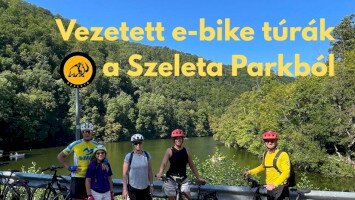
13. SZELETA-BARLANG
A Szeleta-barlang tetőközelbe került fosszilis forrásbarlang, a Bükk hegység legnagyobb ősemberbarlangja. Az itt talált babérlevél alakú kőeszközök alapján nevezik a Bükk más barlangjaira is jellemző eszközkészítő ipart Szeleta-kultúrának. Régészeti kutatások szerint a barlang a középső- és felső-paleolitikumban mintegy száztízezer évig lakott volt. A Szeleta-barlang fokozottan védett természeti érték. Hámorból vagy Lillafüredről piros sáv jelzésű turistaúton érhető el, szabadon látogatható.

14. ANNA- ÉS SZENT ISTVÁN-BARLANG
Lillafüreden található a Bükki Nemzeti Park két idegenforgalom számára megnyitott barlangja. Az Anna-barlang a Szinva karsztforrásának vízéből kivált édesvízi mészkőlerakódásban alakult ki, üregei a vízeséseknél lehajló növényzet alatti fülkék beboltozódásával jöttek létre. A Szent István-barlang jól karsztosodó triász mészkőben képződött. Termeinek többsége nagy magasságú hasadékokban, kürtőkben végződik. A járatokat cseppkőlefolyások, függő és álló cseppkövek, cseppkőoszlopok díszítik. A barlangok látogathatóságáról a www.bnpi.hu oldalon tájékozódhatnak.

15. SEBES-VÍZ FORRÁSOK
Az Ómassáról sárga sáv jelzésű turistaúton közelíthetők meg a Sebes-vízvölgy forrásai. Az Alsó-Sebesvíz-forrás szurdokszerű völgyének édesvízi mészkő (mésztufa) lépcsőin lefutó zuhatagjai különleges látványosságok. A völgy középső szakaszán fakad a szélsőségesen ingadozó vízhozamú Huba-forrás. A forrás alatti nagyobb esésű szakaszon szép mésztufa-gátak épülnek, jellegzetes mohaflórával.A Sebes-víz-völgy a Bükki Nemzeti Park védett területe. Turistaúton szabadon látogatható.

Bükk fennsík
16. OLASZ-KAPUI TANÖSVÉNY
A 7,2 km hosszú tanösvény geológiai, felszínalaktani, botanikai, zoológiai és kultúrtörténeti ismereteket nyújt.
Állomásai:
1. Olasz-kapu
2. Fekete-sár – Zsidórét
3. Tar-kő
4-5. Őserdő
6. Káposztáskerti-beszakadás
7. Káposztáskert-lápa
8. Körös-barlang
Az Olasz-kapui tanösvény a Bükki Nemzeti Park védett és fokozottan védett területén halad.
A kijelölt utakon szabadon látogatható. A bejárás időtartama kb. 3 óra.

17. NAGYMEZŐ – KIS-KŐHÁTI-ZSOMBOLY TANÖSVÉNY
A tanösvény a Bükk-fennsík különleges karsztos formakincséből a Kis-kőháti-zsombolyt és a Nagy-mező karsztvápáját mutatja be.
A tanösvény állomásai:
1. Kis-Kőhát-nyereg (indítótábla)
2. Kis-kőháti-zsomboly
A Bükk egyik legidősebb barlangja, amely néhány százezer évvel ezelőtt víznyelőként működött.
3. Nagy-mező
A hegység legnagyobb karsztvápája töbrökkel, ikertöbrökkel, víznyelőkkel.
Erdőirtás nyomán keletkezett hegyi rét.
A Nagy-mező fokozottan védett természeti terület, a jelzett turistautakon és a tanösvényen szabadon látogatható.

18. JÁVORKÚTI TANÖSVÉNY
Lillafüred felől, a Garadna- majd a Savós-völgyön vezető keskeny műúton gépjárművel Jávorkútig lehet közlekedni. Az indítótábla Jávorkút DNy-i szélén van. A 3 km hosszú tanösvény a kiindulóponthoz tér vissza.
A tanösvény állomásai:
1. Jávorkút (indító tábla)
A jávorkúti tó és az őslucos
2. Ősfenyves
3. Kis-Csipkés
Az Északi- és Déli-Bükk szerkezeti határa
4. Töbörsor
A fedett karsztról a mészkőfelszínre átöröklött eltömődött víznyelők sora.
A tanösvény a Bükki Nemzeti Park védett természeti területén helyezkedik el. A turistautakon szabadon látogatható.

Diósgyőr–Bükkszentlászló–Répáshuta
19. DIÓSGYŐRI VÁR
A területen már a népvándorlás korában is erődítés állhatott, majd a 13. században, a tatárjárás után építették az első várat. Ennek falszerkezetére épült Nagy Lajos király szabályos, négyzet alakú palotája. Zsigmond király idejében emelték a külső vár ikertornyait és a tornyokat összekötő emeletes lakosztályokat, Mátyás korában pedig gazdasági és lakóépületek létesültek. Nagy Lajos király óta Mohácsig a vár a királynék jegyajándéka volt. A programokról és a nyitvatartásról a www.diosgyorivar.hu weboldalon tájékozódhatnak.

20. BÜKKSZENTLÁSZLÓ, NAGYSÁNC
Bükkszentlászló felett emelkedik a Nagysáncnak nevezett magaslat. Mindenfelől meredek oldalak határolják, csak ÉNy felől közelíthető meg egy alacsonyabb nyeregről. A késő bronzkori Kyjatice kultúra alakította ki az erődítés magját és a telep élete a kora vaskorban is folytatódott, majd azi.e. 1. században kelták lakták. Bronzkori és vaskori leletek, vaskori és kelta házmaradványok mellett kelta ezüstpénz leleteket is feltártak. A Nagysánc Bükkszentlászlóról épített úton közelíthető meg. Szabadon látogatható.

21. REJTEK – RÉPÁSHUTA TANÖSVÉNY
A 12 állomásos, körtúra jellegű tanösvény a rejteki Kutatóház parkolójából indul déli irányba a kék ferde sáv jelzésű ősvényen. A 9 km hosszú tanösvény bejárása kb. 4-5 órát igényel. A tanösvény három ősrégészeti szempontból fontos barlangot, mészégetőhelyet, két szurdokvölgyet, a gyertyán-völgyi üveghuta maradványait, a Bükk egyetlen időszakosan működő váltóforrását és két állandó víznyelőt
mutat be. A tanösvény a Bükki Nemzeti Park fokozottan védett területén halad, a kijelölt ösvényen szabadon látogatható.

Szilvásvárad-Bélapátfalva-Szarvaskő
22. SZALAJKA-VÖLGY
A Szalajka-patak 18 lépcsőből álló látványos forrásmészkő lépcsősorán zubog le a Fátyol-vízesés. A völgy egyéb látnivalói: Szikla-forrás, Szabadtéri Erdei Múzeum, pisztráng-keltető tavak, Zilahy Aladár Erdészeti Múzeum és a Bükki Nemzeti Park Igazgatóság Szalajka-völgyi Információs Háza. A kisvasút végállomásától túraösvényen kb. 30 perc alatt érhető el az ősember lakóhelyeként is ismert Istállós-kői-barlang. A Szalajka-völgy a Bükki Nemzeti Park fokozottan védett területe, gyalogosan, kerékpáron és a kisvonattal látogatható.

23. BÉLKŐ ÉS AZ APÁTSÁGI TEMPLOM
Bélapátfalva felett a csaknem száz évig tartó mészkőbányászat által megcsonkított Bél-kő a Bükk peremén emelkedő „kövek” sorozatának nyugati tagja. Északnyugati lábánál 1232-ben alapították a ciszterci szerzetesek a bélháromkúti apátságot. Az apátsági templom formája, alaprajza, arányai a középkori állapotot őrzik. Az apátsági templomtól a Bél-kő csúcsáig vezető tanösvény a hegy kultúrtörténeti, természeti értékeit, földtani felépítését és a bányászat történetét mutatja be. A 7 állomásból álló tanösvény bejárása 1,5-2,5 órát igényel. Szabadon látogatható.

24. SZARVASKŐI GEOLÓGIAI TANÖSVÉNY
Az Eger-patak szűk völgyében épült Szarvaskő települést vulkáni kőzetekből álló meredek hegyoldalak fogják közre. A tanösvény a Bükk délnyugati részének földtani és felszínalaktani szempontból különálló részét, a jura kori palából, a tenger alatti vulkáni kitörések bazaltjából és az egykori tengerfenék üledékeiben megrekedt gabbróból felépülő terület szép feltárásait és a szarvaskői vár romjait mutatja be. A tanösvény 10 állomásból áll, kb. 3-3,5 óra alatt járható be. Nagyrészt a Bükki Nemzeti Park védett és fokozottan védett területén halad. A kijelölt tanösvényen szabadon látogatható.

Eger–Noszvaj–Felsőtárkány
25. EGER, NYERGES-HEGYI KAPTÁRKÖVEK
Eger határában, az Ostoros-patak keleti mellékvölgyében található a Nyerges-tető. A nyugati oldalán lévő kaptárkő tetejét nyereg alakúra képezték ki. A plató felületébe tál alakú mélyedéseket, csatornákat, lyukakat vájtak. A sziklavonulat délkeleti falán és egy különálló tömbön 24 fülke és fülkenyom található. A terület védett természeti emlék, a Kaptárkő Egyesület által kiépített Mész-hegy - Nyerges-tető tanösvényen szabadon látogatható.

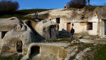
26. NOSZVAJ, POCEM, BARLANGLAKÁSOK
Noszvajon valószínűleg a 19. század elejétől alakultak ki a barlang- és pincelakások. A könnyen megmunkálható riolittufa adta a lehetőséget, fő oka pedig a nagymértékű elszegényedés volt. Ma a barlanglakások, kevés kivétellel lakatlanok, a falu délkeleti részén, a „Pocem”-ben lévők jó részében pedig 1997 óta alkotótelep működik. A művésztelep résztvevői kortársi koncepciók alapján azóta is alakítják a sziklába vájt térformákat. A noszvaji barlanglakások helyi védettséget élvező építészeti emlékek, illetve Noszvaji Farkas-kő kaptárköve természeti emlék. Szabadon látogathatók.

27. FELSŐTÁRKÁNYI TANÖSVÉNYEK
A Felsőtárkány északkeleti szélén lévő tó partjáról három tanösvény indul.
1. A Kő-közi kör a Szikla forrást, a Kő-kőz nevű sziklaszorost és a tavat mutatja be. 800 m hosszú, 5 állomást tartalmaz, bejárásához 1 óra elegendő.
2. A Barát-réti kör a 2,6 km-re lévő Bujdosó-kőig 4 állomáson mutatja be az útvonal érdekességeit.
3. A vár-hegyi kör egy hegycsúcsra és egy hosszú hegygerincre visz fel. 10 km hosszú, 6 állomása van, bejárásához 4-5 óra szükséges.
A tanösvények a Bükki Nemzeti Park területén helyezkednek el, a kijelölt útvonalon szabadon látogathatók.

Szomolya–Bogács–Cserépfalu
28. SZOMOLYAI KAPTÁRKÖVEK
A bükkaljai vulkanizmus kőzeteihez kapcsolódó legjellemzőbb felszíni alakzatok a kaptárkövek. A sziklavonulatokba, kőtornyokba a régmúlt korok emberei még tisztázatlan rendeltetésű fülkéket faragtak. A Kaptár-rét felett húzódó riolittufa vonulat nyolc nagyobb sziklacsoportján 117 fülke található. Legszebb a IV., Királyszékének is nevezett sziklavonulat, amelyen 48 változó nagyságú és mélységű fülke látható. A Szomolyai kaptárkövek természetvédelmi terület a Bükki Nemzeti Park Igazgatóság természetvédelmi és vagyonkezelésében van. Az épített útvonalon szabadon látogatható.

29. BOGÁCSI PINCEFALU
A miocén kori vulkáni tufákon létrejött talajok nyomelemekben, ásványi anyagokban gazdagok, rajtuk zamatos szőlő terem. A könnyen vágható, de állékony kőzetbe vágott pincék pedig kiválóan megfelelnek a bor tárolására. A bogácsi pincesorok több évszázados múltra tekintenek vissza, a Bükkaljai borvidék egyik legjelentősebb helyszíne a bogácsi Cserépi úti pincesor. A pincék nagy többsége borházas pince, a kőbe vágott pince elé felálló falú borházat építettek. A pincefalu gazdag programokkal és nyitott pincékkel várja a vendégeket.

30. CSERÉPFALU, SUBA-LYUK
A Cserépfalu határában lévő Suba-lyuk Múzeum és Látogatóközponttól rövid sétával jutunk el a Hór-völgy meredek oldalában nyíló barlanghoz. Az egyetlen nagy csarnokból álló inaktív forrásbarlang jelentőségét emelik a benne talált neandervölgyi ősemberleletek. A barlangi kitöltésben egy 25-35 éves nő és egy 3 év körüli gyermek csontmaradványai kerültek elő állatcsontok, pattintott kőeszközök és tűz használatára utaló faszénlelet mellett. A Suba-lyuk fokozottan védett természeti érték és régészeti védelem alatt áll. Szabadon látogatható.